- SBIS News
New team members: Last year we were delighted to welcome two new team members. Hannah Alred is our new Ancient Woodland Inventory Officer and is responsible for creating the new Suffolk Ancient Woodland Inventory. Emma Aldous is our new Communications Officer and is responsible for looking after our website, social media, our newsletters and more!
Projects
Lidar derived tree canopy polygon data
Data from NCC is being analysed and we now have tree canopy cover figures for all Suffolk parishes. We are currently working on producing separate figures for woodland and non-woodland, and conifer and broadleaf, using OS MasterMap and Forestry Commission data. Once this is complete analysis to classify hedgerows by gappiness and average height will follow.
Land Cover Map 2020 raster data
This free 25m raster data has been downloaded, mapped and made available internally in GIS. 10m resolution data is also being imported. The data from these will help target action to increase biodiversity.
Supporting Partners
Orchards East
The final version of the Orchards East dataset, with GIS polygons and text for each orchard, was received from Tom Williamson at the University of East Anglia. It incorporates data from the earlier project by Suffolk Traditional Orchards Group (STOG). The data will be available to partners via our download page (Users need to register by contacting SBIS to gain access to the relevant download section). We now attend meetings of the volunteer legacy organisation, Orchards East Forum, in rotation with representatives from other Local Environmental Records Centres. For more information about the work they do visit: www.orchardseastforum.org
Ancient Woodland Inventory update
Working with Natural England, the Suffolk update is now well underway, with all necessary data imported and processed. See our full report on the progress of the current phase and outlines of the future phases of the Ancient Woodland Inventory project.
Native Black Poplar
We are working with Sue Hooton (Suffolk's Native Black Poplar recorder) to create an online map, verification and recording portal on the SBIS website for the Suffolk Tree Warden Network and surveyors.
County Wildlife Sites and Roadside Nature Reserves
Suffolk Wildlife Trust are continuing to re-write many CWS citations which we are incorporating into our database. Maintenance of the CWS and RNR GIS datasets continues but there have been no major changes over the past few years.
GIS biodiversity data updates are made available twice yearly for download by partners (notified by email) from www.suffolkbis.org.uk/downloads. Users need to register by contacting SBIS to gain access to the relevant download section where partners can download the full update of Species, Sites and Orchards East boundaries (in 2 formats: MapInfo TAB or ESRI Shapefile with site citations in Access, Excel or PDF format), or just the County Wildlife Site, Roadside Nature Reserve and County GeoSite update.
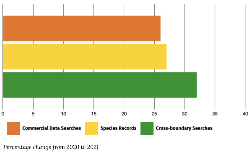
Commercial Data Enquiries
Over the last year we have seen a 26% increase in commercial data enquiries, from 509 in 2020 to 643 in 2021. This resulted in a 27% increase in species records being sent to ecological consultants, from 476,559 in 2020 to 607,384 in 2021. We also saw a 32% increase in cross-boundary searches shared with neighbouring record centres, from 37 in 2020 to 49 in 2021.
- Surveying our Geological SSSIs • Caroline Markham, GeoSuffolk
Over the last two years GeoSuffolk has been contracted by the Geology Trust to survey some of Suffolk’s geological SSSIs for Natural England. So far, we have surveyed seventeen – eleven of these designated for exposures of Pliocene Coralline and Red Crags and six for younger Pleistocene deposits. This work is done in winter – to minimise disturbance to wildlife, also because there is less vegetation obscuring the geological exposures. We have been most fortunate to have access to these geosites during the variety of lockdown conditions of the last two winters – fascinating geology and work in the open air!
Geological SSSIs are designated for their research interest and our (geologically) young deposits in Suffolk have generated much interest lately due to their relevance to climate change. GeoSuffolk’s job was to assess the quality and accessibility of the exposures for future research. We had the citation for their designation from the NE website, naturalengland.org.uk, arranged a site visit with the landowner and made a photographic record of the features in the citation that we could find on site plus any new features of interest. We also assessed constraints to study – vegetation and talus build-up in particular and made recommendations on their future management to Natural England.
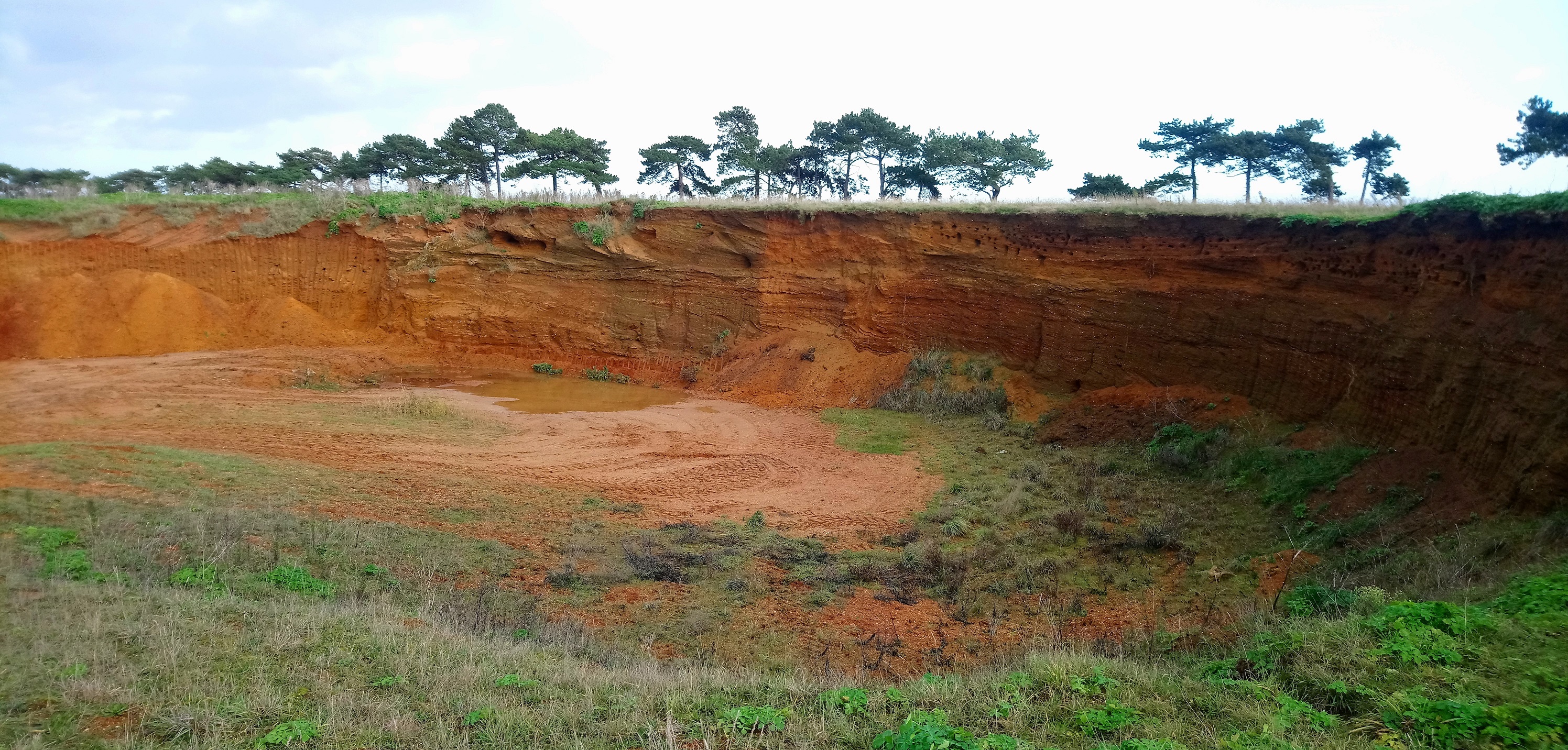
Buckanay Farm pit SSSI This was an easy and enjoyable task in many of the disused crag pits, most of which are in good condition. Buckanay Farm pit SSSI in Alderton for example is one of those Suffolk Red Crag pits which open up in quite an astonishing way from relatively flat ground. It displays a variety of sedimentary structures plus an almost bewildering array of fragmented fossil molluscs. It is on private land but can be glimpsed from the footpath between Alderton and Shingle Street as in the photo, taken when we did the survey in December 2020.
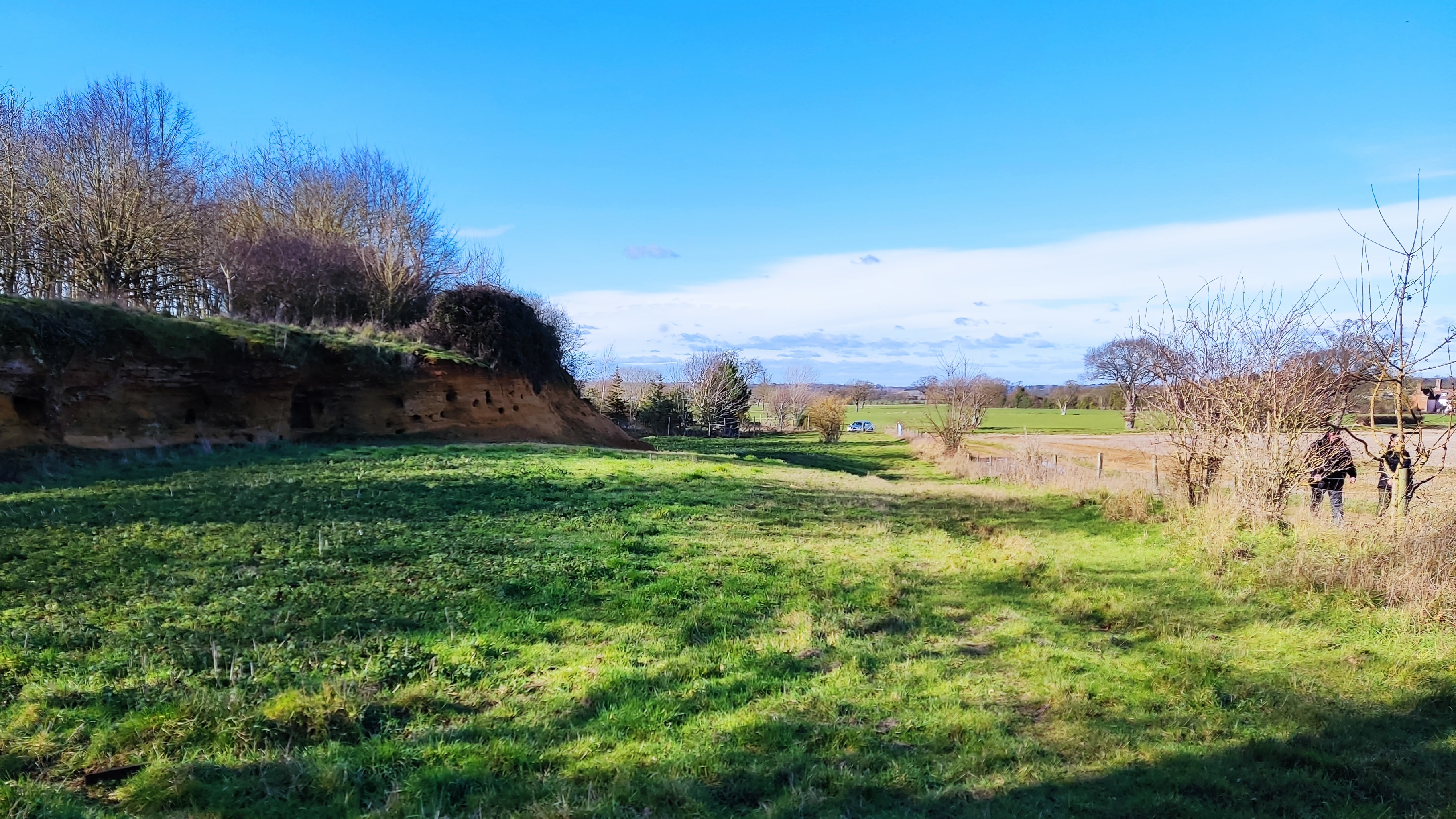
Rockhall Wood pit SSSI Rockhall Wood pit SSSI in Sutton, whist being enjoyable was far from simple. To do justice to the citation, which finished with ‘In the study of Pliocene geology this is probably the most important site in Britain’, we took 50+ photographs all of which had to be described and given eight-figure grid references. Fortunately, we are familiar with this site as GeoSuffolk has done much site management here in the past. It is still in very good condition. showing its almost complete Coralline Crag stratigraphy right up to the unconformity with the Red Crag. It is a large site comprising an outlier of Coralline Crag with quarries on three sides - the photo was taken when we did the survey in February 2022 and shows the north face exposure of Coralline Crag, which is may be seen from the footpath (with two people walking on it).
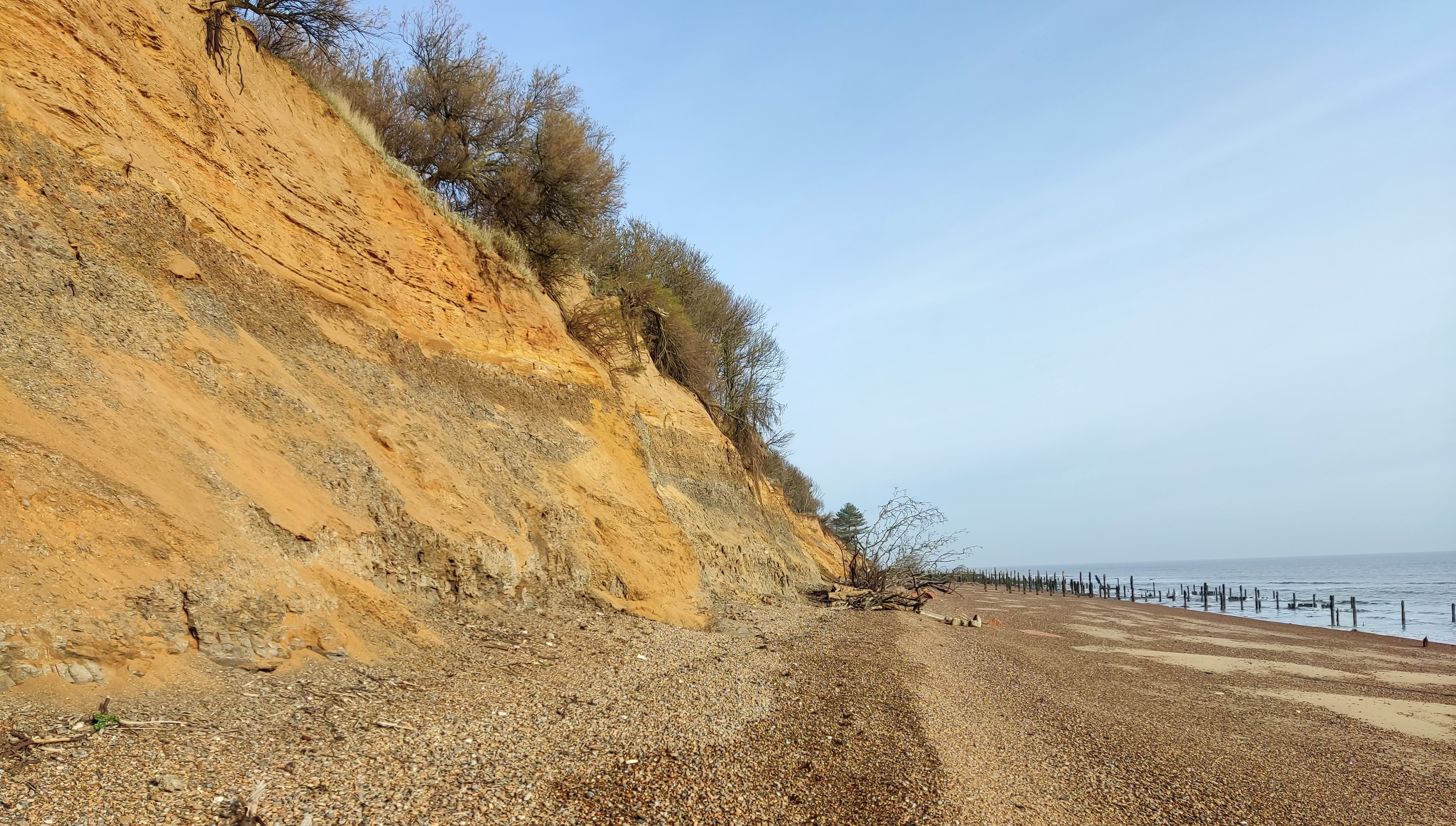
Bawdsey Cliff SSSI You would think, having visited it in summer 2018 that we would be familiar with details of the Red Crag exposures in Bawdsey Cliff SSSI. However, in January 2022 they were unrecognisable, such was the erosion over the intervening 3+ years. The Red Crag sedimentary structures and fossils in the citation are still visible, but the beach has been lowered such that the unconformity with the London Clay is now generally 3-4 metres above the beach.
This renders the Red Crag inaccessible high up in the cliff – as in the photograph taken on our survey. The geology of the SSSI received a good report from us but we advised NE that access along the shore could soon become difficult from both north and south because of beach lowering. We only had 1½ hours either side of low tide to complete our survey. it was a fabulous walk and we saw not another soul save our four GeoSuffolk companions but thank goodness for the wonderful January weather this year!
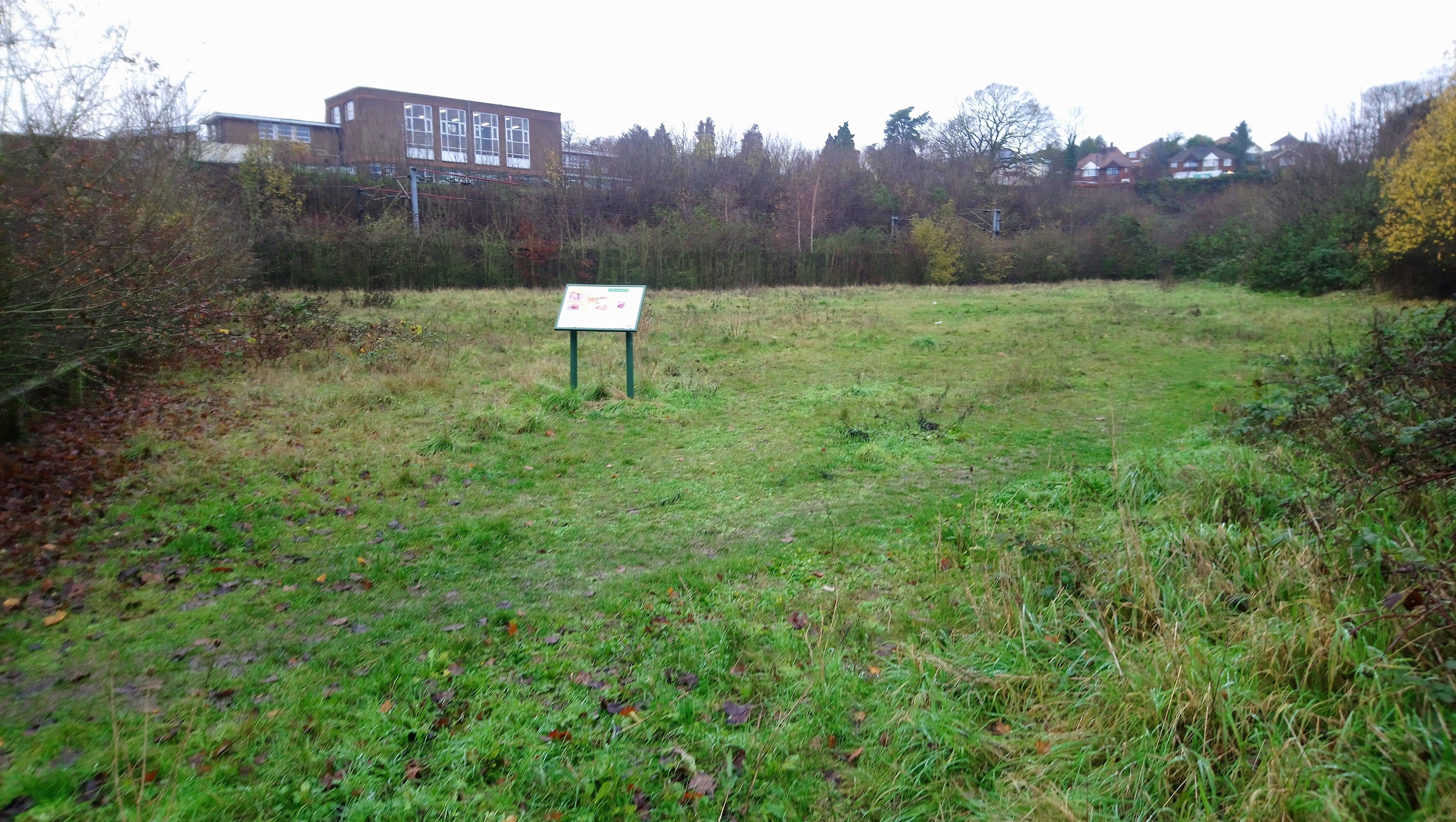
Stoke Tunnel Cutting SSSI Last year it was not so good, and snow dogged our attempts to survey our final site of 2021. Stoke Tunnel Cutting in Ipswich is designated to protect the interglacial lake bed deposits discovered when the railway tunnel was dug in the 1840s. These have been dated at approx. 210,000 years old and have yielded a variety of vertebrate fossils. The railway line splits the site in three, only one of which, a protected open space in a residential development, was easy to access.
On the other side of the railway line the SSSI lies within Hillside School grounds, so we had to wait till the end of the winter 2021 lockdown – and then it snowed! We did get there in the end, but as for the railway cutting itself, Network Rail were very accommodating and said we could visit it between 01.30 and 04.00! We opted for photos (in daylight) from an access gate close to the tunnel. The photo shows GeoSuffolk’s interpretation panel at Worsdell Close, the grassed area protects the Pleistocene deposit – a lake bed is a finite resource, so not to be exposed unless necessary. Hillside school is in the background (across the railway line) and in the distance to the right the houses on top of the railway bridge can be seen.
- An update on river habitat enhancement work • Naomi Boyle, Environment Agency
The Environment Agency ‘Environment Programme Team’ has been working with partners at Essex & Suffolk Rivers Trust and the River Waveney Trust to deliver river habitat enhancements. These improvements are required to help our rivers achieve ‘good’ status under the Water Framework Directive. This work has been funded through Defra’s Water Environment Improvement Fund.
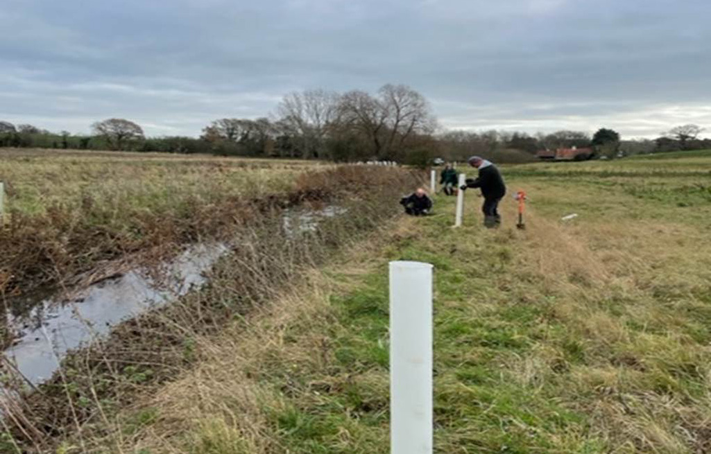
River Ore at Parham with Essex & Suffolk Rivers Trust
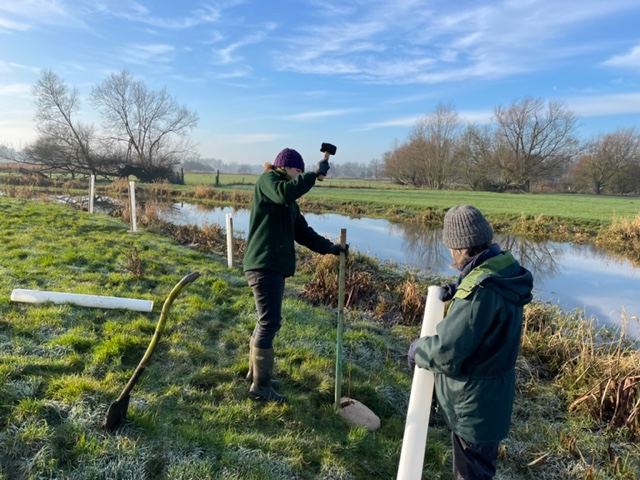
River Waveney at Homersfield with the River Waveney Trust Works being carried out this winter include a cattle crossing on the River Alde to reduce sediment entering the river, brushwood bundles and the creation of a marginal bay on the Earl Soham watercourse to increase flow and habitat diversity as well as a floodplain scrape. In addition to this over 500 native trees and scrub have been planted alongside the Rivers Alde, Ore, Deben, Waveney, Dove and the Earl Soham watercourse. These will not only provide habitat enhancement but will help to keep our rivers cool, provide bank stability and a buffer to any nutrient and sediment enriched runoff entering these rivers.
- Urban Greening in Felixstowe • Dr Adrian Cooper
Urban greening is a process of increasing the amount of land given over to trees and plants which help local wildlife. Ideally, urban greening involves planting designated areas of land with new trees and other plants. However, it may also be developed where pioneer individuals and groups start to grow new wildlife-friendly plants in small urban spaces. When others join in those initiatives, green corridors may develop. Then green networks may follow on.
In the Felixstowe area, we have successfully developed our urban greening project since May 2015. We call it Felixstowe’s Community Nature Reserve (FCNR). It was begun as an attempt to stop the decline in local wildlife populations. FCNR has three aims which may be summarized as follows:
- To educate local people about the decline in local wildlife, and what each local person can do to stop that decline.
- To start growing new trees and plants within at least 3 square yards of their back gardens, or allotments. Additional examples of wildlife-friendly activity include re-wilding of at least 10% of garden/allotment areas, and the building of wildlife ponds, hedgehog homes and tunnels, and insect lodges.
- To help and encourage as many others as possible with these activities.
For local people who live in flats, FCNR recommends that they take part in this work by growing plants such as herbs and roses in pots on their balcony.
At the time of writing, FCNR has just over 1,700 active members. The average allocation of space for wildlife-friendly activity is 3.65 square yards. Collectively, this means that FCNR has the area of a full-sized football pitch.
In May 2020, the Felixstowe Citizen Science Group conducted an Impact Analysis on the work of FCNR. The analysis sampled the experience of improved biodiversity within the gardens of 100 members of the Community Nature Reserve. The survey showed that 62% of people in that sample found an increase in the biodiversity in their gardens since they became members of FCNR. The survey also found that 68% of surveyed members grow at least one of the plants recommended by FCNR in their Facebook page. Equally, 66% of people in the survey grow plants which are targeted at helping local bees. A full version of this impact analysis can be found on the Community Nature YouTube channel under the title of Impact Analysis 2020.
In the first few months of 2021, the RSPB published a feature on FCNR in their Nature’s Home magazine: a publication which is distributed to 400,000 RSPB members. That publication helped with the diffusion of FCNR’s ideas. At the time of writing, there are ten other groups across the UK which have adopted and adapted the urban greening ideas of FCNR. They are:
- Ipswich Community Nature Reserve
- Transition Woodbridge
- Bredfield Wildlife-Friendly Village
- Newmarket Community Nature Reserve
- Brightlingsea Nature Network
- Burton Latimer Community Nature Reserve
- Calne Community Nature Reserve
- Hitchin Nature Network
- Cosby Community Nature Reserve
- Hadleigh Environment Action Team
In addition, FCNR has influenced the establishment of the Pontos and Vida conservation project in Portugal.
To further develop their work, FCNR appointed a Schools Ambassador in the summer of 2021 to promote urban greening among local school children. That promotional work included the start of a Wildlife Writing, Photography and Art competition. An early product of that initiative led to some local school children’s creative writing being read out on the Felixstowe Radio station. Other targeted projects with local children are planned for 2022.
FCNR has also started to encourage local business people to plant trees within the grounds of their organizations, and to also grow more trees in their home gardens. In return, FCNR publicizes those businesses as a sign of appreciation for that work.
Despite the encouraging results of this work, FCNR members still encounter cynicism from a few local people. Those cynics sometimes ask why it is necessary for an independent voluntary group, such as FCNR, to do this work. The reply, quite simply, is that no other organization is doing this kind of grass-roots environmental work in our area. Other cynics question why any example of urban greening matters. In reply, members explain that the community nature reserve offers a legacy to the local area which will benefit the children, grandchildren, nieces and nephews of all local people.
As an organization, FCNR encourages local people to feel empowered to start and develop new projects without the need to discuss those plans with any centralized leadership. This decentralized form of power helps to make the community nature reserve as sustainable as possible. Examples of those micro-level projects include plant swapping, garden pot swapping and even garden cane swapping. It also includes examples of assistance, advice and support between members. In this way, FCNR can be thought of as a multi-project environment. That is, within the overall FCNR project, there is a myriad of micro projects being developed in ways which suit local members.
Felixstowe’s Citizen Science Group was established in April 2018 to quantify and analyze the work of FCNR. In addition to the Impact Analysis discussed above, the local citizen scientists try to complete at least one new project each month. The results of that work may be viewed on the Felixstowe Citizen Science Group Facebook page.
A major part of the innovation process for FCNR arises through their membership of the National Biodiversity Network: the UK’s largest network of conservation groups. Felixstowe’s Citizen Science Group is also a Network Supporter of the European Citizen Science Association. In this way, new ideas from a wide catchment area are drawn into local work in the Felixstowe area.
The main conclusion to be drawn from this discussion is that FCNR has established an approach to urban greening which appears to be successful and sustainable. While there is no room for complacency, there is a place for hope within the future strategies of urban greening in the UK and beyond. Encouraging youth participation will be essential to that work.